Appendix B: Attributes in the 2007 Washington State Forestland Database
Product description
The 2007 Washington State Forestland Database is an ArcGIS 9.3 Personal Geodatabase that can be accessed using any of the programs in the ESRI ArcGIS product suite or using Microsoft Access. The spatial components of the database are not accessible via MS Access.
Database Design
The database consists of four separate features: the Forestland table and the County, WRIA and WAU feature classes for thematic mapping (Figure 10). Each of the three feature classes can be joined or related to the Forestland table (Table 19).
Table 19: Forestland Database primary/foreign key relationships for thematic mapping.
| From |
To |
| Forestland_2007.COUNTY_ID |
County_2007.JURDSG |
| Forestland_2007.WRIA_NR |
WRIA_2007.WRIA_NR |
| Forestland_2007.WAU_CD |
WAU_2007.WAU_CD |
To create thematic maps using the Forestland Database summary statistics must first be run on the data. For example to create a map of the percent of each WRIA that is owned by Small Forest Landowners a new “make table” query must be run to make the table that will be joined to the WRIA feature class for mapping. The query in Microsoft Access would be:
SELECT Forestland_2007.WRIA_NR, Sum([Forestland_2007].[GIS_ACRES]/[WRIA_2007].[WRIA_ACRES]) AS PERCENT_SFLO INTO WRIA_Percent_SFLO
FROM Forestland_2007 INNER JOIN WRIA ON Forestland_2007.WRIA_NR = WRIA_2007.WRIA_NR
WHERE (((Forestland_2007.WA_SFLO)="SFLO"))
GROUP BY Forestland_2007.WRIA_NR;
The newly created “WRIA_Percent_SFLO” table can then be joined to the WRIA feature class for thematic mapping in ArcGIS.
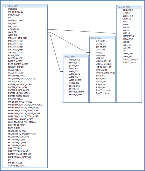 |
| Figure 10: Washington State Forestland Database Entity Relationship Diagram. |

Attributes
Datasets referenced with superscripts are described in Appendix C: GIS Datasets Used.
FORESTLAND_ID: The unique identifier for each parcel created in the data export process. Each identifier is a 128 bit GUID (globally unique identifier) represented as a 38 character string.
Land Use
LANDUSECD: The land use as assessed by each County Assessor. County values were normalized to fit the Washington State ‘Standard two‐digit land use code’ values as defined in WAC 458‐53‐30. Values range from 1 to 99.
DFL: Whether or not each parcel is enrolled in the Designated Forestland Tax Program. This is determined by its land use code. A land use code value of 87 or 88 indicates that the parcel is participating in the program. Values: 1 or Null.
Ownership Classification
OWNER_CLASS: The type of owner for each property. This was determined by examining the owner name for each parcel, comparing it to a categorized, exhaustive list of names, and placing the parcel into a category. Values: Government, Corporate, Tribal, Conservation, Other Private.
Management Type
WA_NIPF: The management type using the NIPF definition, "total individual land ownerships of less than 5000 acres and not directly associated with wood processing or handling facilities". Values: NIPF, Industrial, or Null.
NIPF: A parcel that meets NIPF definition, "total individual land ownerships of less than 5000 acres and not directly associated with wood processing or handling facilities", and does not have a corporate or government owner.
Industrial: A parcel that does not meet the NIPF definition, "total individual land ownerships of less than 5000 acres and not directly associated with wood processing or handling facilities", meaning the parcel owner owns more than 5000 acres in the State. The parcel also has a corporate owner, and is non‐government.
WA_SFLO: The management type using the Washington State Small Forest Landowner definition as defined in RCW 76.09.450 (harvesting no more than an average of 2 million board feet of timber per year). Values: SFLO, Industrial, Tribal_SFLO, or NULL. While the Forestland Database has parcels down to 1 acre in size, the Database’s SFLO definition requires the smallest properties to be at least 2 acres in size (tract acres) with a minimum of 1 acre of forest cover. Parcels with forested land uses as defined by county assessors were classified as SFLO up to the acreage limits regardless of minimum size cutoffs (land uses 87, 88, 92 and 95, see Appendix F: Land Use Codes in the Washington State Forestland Database).
SFLO: A parcel that meets the Washington State Small Forest Landowner definition as defined in RCW 76.09.450 (harvesting no more than an average of 2 million board feet of timber per year). This is estimated by determining the number of acres in management an owner would need to meet this level of productivity. On the west side of the state, an owner would need 2500 acres, and on the eastside 9990 acres. A parcel whose owner owns less than 2500 acres on the west side of the state, or a parcel whose owner owns less than 9990 acres on the east side of the state would qualify. The parcel owner must also be non‐corporate and non‐government.
Industrial: A parcel that does not meet the Washington State Small Forest Landowner definition as defined in RCW 76.09.450 (harvesting no more than an average of 2 million board feet of timber per year). This is estimated by determining the number of acres in management an owner would need to meet this level of productivity. On the west side of the state, an owner would need 2500 acres, and on the eastside 9990 acres. A parcel whose owner owns at least 2500 acres on the west side of the state, or a parcel whose owner owns at least 9990 acres on the east side of the state would qualify. The parcel owner must also be corporate and non‐government.
Tribal_SFLO: A parcel that meets the Washington State Small Forest Landowner definition as defined in RCW 76.09.450 (harvesting no more than an average of 2 million board feet of timber per year). This is estimated by determining the number of acres in management an owner would need to meet this level of productivity. On the west side of the state, an owner would need 2500 acres, and on the eastside 9990 acres. A parcel whose owner owns less than 2500 acres on the west side of the state, or a parcel whose owner owns less than 9990 acres on the east side of the state would qualify. The parcel owner must also be tribal, non‐corporate, and non‐government.
Physical Attributes
COUNTY_ID: The ID number of the County in which each parcel is located. The county boundary dataset was created by the Washington Department of Natural Resources1.
WAU_CD: The ID number of the WAU (Watershed Administrative Unit) in which each parcel is located. The WAU dataset was created by the Washington Department of Natural Resources2.
WRIA_NR: The ID number of the WRIA (Water Resource Inventory Area) in which each parcel is located. The WRIA dataset was created by the Washington State Department of Ecology3.
STREAM _TOTAL_FEET: The total length in feet of all watercourses on a parcel. The watercourse data was created by the Washington Department of Natural Resources4.
STREAM_F_FEET: The total length in feet of all type F watercourses on a parcel. The type F designation is a DNR Forest Practices Fish Habitat Water Type Code, implemented for Western Washington March 1, 2005, and for Eastern Washington March 1, 2006. It is used in conjunction with WAC 222‐16‐030 and 222‐16‐031 and the Washington Forest Practices Board Manual. The watercourse data was created by the Washington Department of Natural Resources4.
STREAM_S_FEET: The total length in feet of all type S watercourses on a parcel. The type S designation is a DNR Forest Practices Fish Habitat Water Type Code, implemented for Western Washington March 1, 2005, and for Eastern Washington March 1, 2006. It is used in conjunction with WAC 222‐16‐030 and 222‐16‐031 and the Washington Forest Practices Board Manual. The watercourse data was created by the Washington Department of Natural Resources4.
STREAM_N_FEET: The total length in feet of all type N watercourses on a parcel. The type N designation is a DNR Forest Practices Fish Habitat Water Type Code, implemented for Western Washington March 1, 2005, and for Eastern Washington March 1, 2006. It is used in conjunction with WAC 222‐16‐030 and 222‐16‐031 and the Washington Forest Practices Board Manual. The watercourse data was created by the Washington Department of Natural Resources4.
STREAM_U_FEET: The total length in feet of all type U watercourses on a parcel. The type U designation is a DNR Forest Practices Fish Habitat Water Type Code, implemented for Western Washington March 1, 2005, and for Eastern Washington March 1, 2006. It is used in conjunction with WAC 222‐16‐030 and 222‐16‐031 and the Washington Forest Practices Board Manual. The watercourse data was created by the Washington Department of Natural Resources4.
STREAM_X_FEET: The total length in feet of all type X watercourses on a parcel. The type X designation is a DNR Forest Practices Fish Habitat Water Type Code, implemented for Western Washington March 1, 2005, and for Eastern Washington March 1, 2006. It is used in conjunction with WAC 222‐16‐030 and 222‐16‐031 and the Washington Forest Practices Board Manual. The watercourse data was created by the Washington Department of Natural Resources4.
ROAD_FEET: The total length in feet of all roads on a parcel. The road data was created by the Washington Department of Natural Resources5.
PARCEL_ACRES: The total acreage calculated by the GIS software for the geometry of each parcel.
FOREST_ACRES: The total acreage of forest on each parcel. This was calculated in one of two ways:
- Using the NLCD Forest/Non‐Forest dataset6. The NLCD data was intersected with the parcel geometry to determine the amount of forest within each parcel.
- Using the parcel land use code. It is assumed that if a parcel is in a designated forestland tax program, that the entire acreage is managed as forest even if some portion of the parcel is non‐forest in the NLCD dataset. The full parcel acreage is considered to be forest in this scenario.
NLCD_FOREST_ACRES: The acres of forest using only the NLCD Forest/Non‐Forest dataset6. This eliminates the second method used to calculate FOREST_ACRES above, and does not consider enrollment in a designated forestland tax program.
PERCENT_FOREST: The percentage of the total acreage that is Forest for each parcel. This is calculated by dividing the FOREST_ACRES by the PARCEL_ACRES.
TRACT_ACRES: Contiguous properties owned by the same owner are called a tract. A tract can be a single parcel. This is the acreage of the tract in which a parcel is a member.
TRACT_AP_RATIO: A measurement of the “parcelization” of ownership tracts (contiguous properties owned by the same owner). It is the sum of the areas of parcels in a tract divided by the sum of the perimeters of parcels in a tract. Values: 2 to 5772.
MAX_NAME_ACRES: A best attempt to determine ownership acres, the total acreage owned by the owner of each parcel within that parcel’s county. Counties may use either taxpayer or owners for each parcel, so this attribute could not be named Ownership Acres. Each parcel may also have more than one owner. The total acreage owned in the county is calculated for each owner of a parcel, and the largest total acreage of the multiple owners is used.
MAX_NAME_ACRES_FORESTED: The same as MAX_NAME_ACRES, but for acres of forest, not parcel acres.
WATER_ACRES: The total acreage of each parcel that is water (waterbodies or wetlands). This attribute was derived using the Washington Department of Natural Resources waterbodies7 and wetlands8 datasets.
BUFFER_WETLAND_ACRES: The total acreage of each parcel that is in wetland buffers. This attribute was calculated using the Washington Department of Natural Resources wetlands8 and Site Class9 datasets, and using the Forest Practices Riparian Management Zone rules as defined in WAC 222‐30.
BUFFER_CORE_ACRES: The total acreage of each parcel that is in core buffers. This attribute was calculated using the Washington Department of Natural Resources waterbodies7, watercourses4, east/west dividing line10, and Site Class9 datasets, and using the Forest Practices Riparian Management Zone rules as defined in WAC 222‐30.
BUFFER_INNER_ACRES: The total acreage of each parcel that is in inner buffers. This attribute was calculated using the Washington Department of Natural Resources waterbodies7, watercourses4, east/west dividing line10, and Site Class9 datasets, and using the Forest Practices Riparian Management Zone rules as defined in WAC 222‐30.
BUFFER_OUTER_ACRES: The total acreage of each parcel that is in outer buffers. This attribute was calculated using the Washington Department of Natural Resources waterbodies7, watercourses4, east/west dividing line10, and Site Class9 datasets, and using the Forest Practices Riparian Management Zone rules as defined in WAC 222‐30.
BUFFER_TOTAL_ACRES: The total acreage of each parcel that is in any type of Forest Practices buffer. This is calculated by summing the core, inner, outer, and wetland buffer acreages.
UPLAND_ACRES: The total acreage of each parcel that is not water or Forest Practice buffer.
FORESTED_WATER_ACRES: The total acreage of each parcel that is both water, as defined in WATER_ACRES above, and forest, as defined in FOREST_ACRES above.
FORESTED_BUFFER_WETLAND_ACRES: The total acreage of each parcel that is both wetland buffer, as defined in BUFFER_WETLAND_ACRES above, and forest, as defined in FOREST_ACRES above.
FORESTED_BUFFER_CORE_ACRES: The total acreage of each parcel that is both core buffer, as defined in BUFFER_CORE_ACRES above, and forest, as defined in FOREST_ACRES above.
FORESTED_BUFFER_INNER_ACRES: The total acreage of each parcel that is both inner buffer, as defined in BUFFER_INNER_ACRES above, and forest, as defined in FOREST_ACRES above.
FORESTED_BUFFER_OUTER_ACRES: The total acreage of each parcel that is both outer buffer, as defined in BUFFER_OUTER_ACRES above, and forest, as defined in FOREST_ACRES above.
FORESTED_BUFFER_TOTAL_ACRES: The sum of the forested core, inner, outer, and wetland buffers.
FORESTED_UPLAND_ACRES: The total acreage of each parcel that is both upland, as defined in UPLAND_ACRES above, and forest, as defined in FOREST_ACRES above.
LOW_GRADIENT_FISH_STREAM: Parcels with a Forest Practices type S watercourse or Water Body from the DNR hydro datasets present. The type S designation is a DNR Forest Practices Fish Habitat Water Type Code, implemented for Western Washington March 1, 2005, and for Eastern Washington March 1, 2006. It is used in conjunction with WAC 222‐16‐030 and 222‐16‐031 and the Washington Forest Practices Board Manual. The watercourse and Water Body datasets were created by the Washington Department of Natural Resources4, 7. Values: 1 or NULL.
LAKEFRONT_TRACT: Parcels that are within a half mile of a ten acre or larger lake in the Washington Department of Natural Resources Water Body7 dataset, and are part of a tract (contiguous properties owned by the same owner) that intersects these lakes. Values: 1 or NULL.
NEAR_ROAD: Parcels that are 600 feet or less from a major road. Major roads were selected from the Washington Department of Natural Resources transportation dataset5 that were: primary highway/all‐weather/hard surface, secondary highway/ all‐weather/ hard surface, light‐duty road/ all‐weather/ improved surface. Values: 1 or NULL.
PROXIMITY_TO_UGA: The distance of each parcel to urban growth areas likely has an effect on its viability as a managed forest. Therefore the straight‐line distance in miles from each parcel to the nearest urban growth area was measured. The urban growth area boundary dataset11 was created and is maintained by the Washington Department of Community, Trade & Economic Development (CTED). Values: 0 to 73 miles.
PROXIMITY_TO_DEVELOPMENT: The distance of each parcel to developed land uses likely has an effect on its viability as a managed forest. Therefore the straight‐line distance in miles was measured from each parcel to the nearest parcel with a developed land use code. Developed land uses are those with an assessed land use code less than 80. The land use is assessed by each County Assessor. County values were normalized to fit the Washington State ‘Standard two‐digit land use code’ values as defined in WAC 458‐53‐30. Land use code values range from 1 to 99.
Values: 0 to 28 miles.
PROXIMITY_TO_ROADS: The straight‐line distance in miles from each parcel to the nearest major road. Major roads were selected from the Washington Department of Natural Resources transportation dataset5 that were: primary highway/all‐weather/hard surface, secondary highway/ all‐weather/ hard surface, light‐duty road/ all‐weather/ improved surface. Values: 0 to 19 miles.
PROXIMITY_TO_DFL: The straight‐line distance in miles from each parcel to the nearest designated forestland parcel Designated Forestlands are identified by their Land Use Code: 87 (not presently assigned [formerly classified forest land under chapter 84.33 RCW]) or 88 (designated forest land under chapter 84.33 RCW). Values: 0 to 56 miles.
PROXIMITY_TO_DNR: The straight‐line distance in miles from each parcel to the nearest Washington Department of Natural Resources managed timberland. The managed timberland data were created by the Washington Department of Natural Resources in the DNR Managed Land Parcels dataset12. Values: 0 to 37 miles.
PROXIMITY_TO_FED: The straight‐line distance in miles from each parcel to the nearest Federal ownership. This could include the US Forest Service, US Fish & Wildlife Service, US Federal Service, US Bureau of Reclamation, US Bureau of Land Management, National Park Service, or other (excludes Department of Defense and Department of Energy). Federal ownership data were created by the Washington Department of Natural Resources in the Washington State Non‐DNR Major Public Lands dataset13. Values: 0 to 30 miles.
Economic Attributes
MARKET_VALUE: The value of each parcel (land and improvements) on the market today, as assessed by each County Assessor. Designated Forest Lands are not assessed. A market value was not directly available for all counties depending on how each Assessor collects data. For some counties market values were derived through some combination of the market value of improvements, market value of improved land, market value of unimproved land, and market value of timberland. For some counties, market values were not available. Values: $0 to $1,219,546,100.
MARKET_VALUE_LAND: The value (land only) of each parcel on the market today, as assessed by each County Assessor. Designated Forest Lands are not assessed. Values: $0 to $609,896,900.
FOREST_VALUE_METHOD: The method used to quantify the amount of forest cover on an individual parcel for calculation of the FOREST_VALUE. Parcels with forested land use codes of 87, 88, 92 and 95 were classified as completely forested as any non‐forested portions as detected by the NLCD land cover were assumed to be planted and in reproduction. Parcels with non‐forest land use codes were assumed to have forest only on the portions of the parcel as detected by NLCD land cover data and no reproduction was assumed. Values: Entire Parcel; Forest Cover Only.
BDFT_ANNUAL_HARVEST: The average annual productivity (final harvest / rotation length) for each parcel in board feet, based on a modeled forest management scenario of site class, buffers, wetlands, location and management type. Values: 0 to 106,523,366.
IRR: The yield on investment per parcel, based on a modeled forest management scenario. Values: 0% to 15.28%.
FOREST_VALUE: The net present value of a modeled forest management scenario for each parcel (the soil expectation value at a five percent discount rate). Values: ‐$9,873,830 to $429,748,962.
CONVERSION_RISK: An estimate of how likely each parcel is to change from forest to non‐forest use. The difference between per acre Market Value and per acre Forest Value for each parcel. Values: ‐$4795 to $26,690,335 per acre.
|