|
 |
 |
 |


|
*Return to the Table of Content
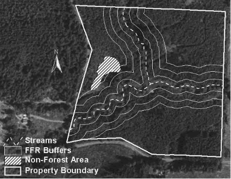
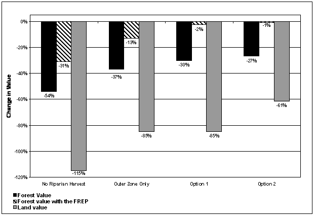
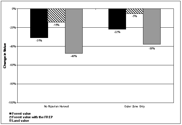
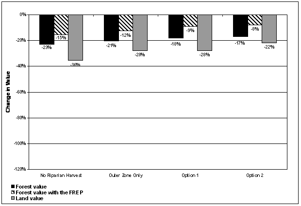
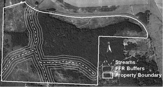
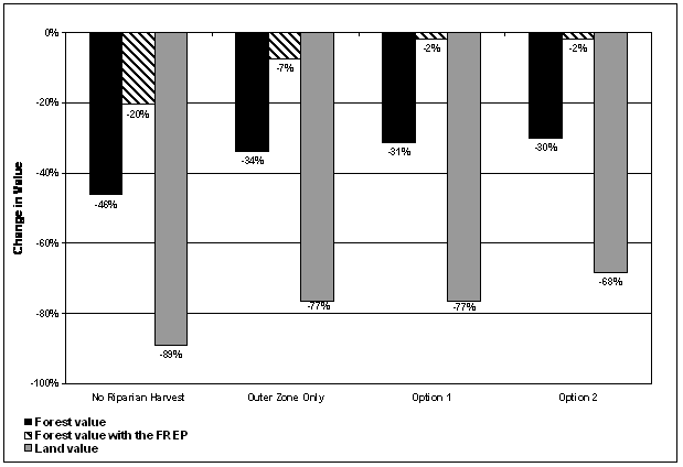
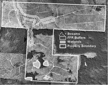
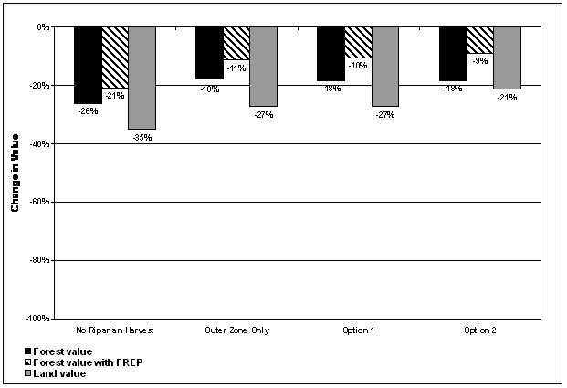
A.1 CASE STUDY 1Case Study 1 (Figure A.1.1) is a parcel with approximately 32.5 acres of commercial forestland located in Lewis County, WA. Most of the timber is a 20-year-old Douglas-fir plantation, with a few pockets of 40-year-old Douglas-fir as well as some areas of lodgepole pine. Site quality is class II, for which the FFR requires a total riparian buffer width of 170 feet on each side of a fish-bearing stream. A small fish-bearing stream runs east to west across the property, with another small fish-bearing stream joining up with it from the north. This leaves a total of 49% of the commercial forest acreage impacted by riparian buffers under the FFR, with 35% in the core and inner zones (Table A.1.1). Economic impacts for Case Study 1 are summarized in Table A.1.2, Figure A.1.2, and Figure A.1.3.
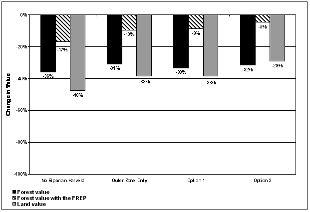
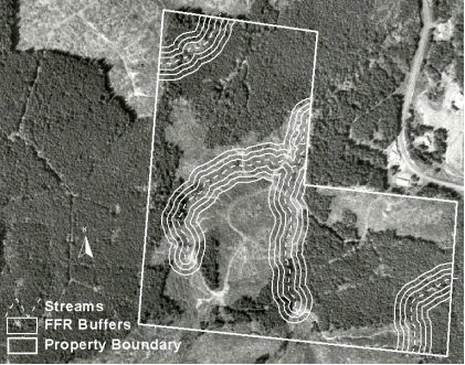
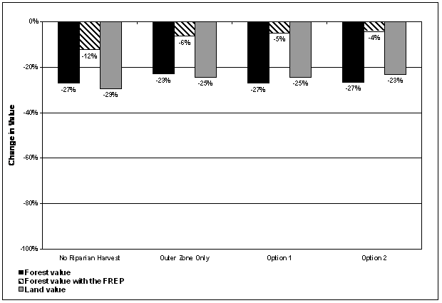
A.2 CASE STUDY 2Case Study 2 (Figure A.2.1) is a parcel with approximately 156 acres of commercial forestland located in Lewis County, WA. Most of the timber is Douglas-fir that is 40 to 45 years old. There are also several stands of 10-year-old timber and a small stand of 100-year-old alder in the southwest corner that is separated by a county road from the rest of the property. The property is site class II, for which the FFR requires a total riparian buffer width of 170 feet on each side of a fish-bearing stream. There is a small fish-bearing stream that runs north to south, with several small streams flowing into it from the east that are also considered fish-bearing. The main stream passes under the road and empties into another stream in the alder stand in the southwest corner of the property. A total of 26% of the property is impacted by riparian buffers under the FFR, with 18% in the core and inner zones (Table A.2.1). Economic impacts for Case Study 2 are summarized in Table A.2.2, Figure A.2.2, and Figure A.2.3. Unlike the upland areas, the riparian zones are dominated by hardwoods. A separate inventory was compiled for these areas. According to the DFC Worksheet, the riparian zones have inadequate conifer basal area to permit any inner zone harvesting. Thus, options 1 and 2 are not applicable for this case study. 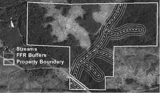
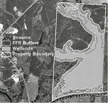
A.3 CASE STUDY 3Case Study 3 (Figure A.3.1) is comprised of three noncontiguous parcels with approximately 67.8 acres of commercial forestland located in Lewis County, WA. Most of the timber is a 5-year-old plantation with a mix of Douglas-fir, grand fir, and western redcedar. The property is site class III, for which the FFR requires a total riparian buffer width of 140 feet on each side of a fish-bearing stream. Two of the parcels include a wetland that has fish-bearing streams flowing through it. Above certain points these streams are considered nonfish-bearing, for which only a 50-foot buffer is required. A total of 31% of the commercial forest acreage is impacted by riparian buffers under the FFR, with 25% in the core and inner zones (Table A.3.1). Economic impacts for Case Study 3 are summarized in Table A.3.2, Figure A.3.2, and Figure A.3.3. 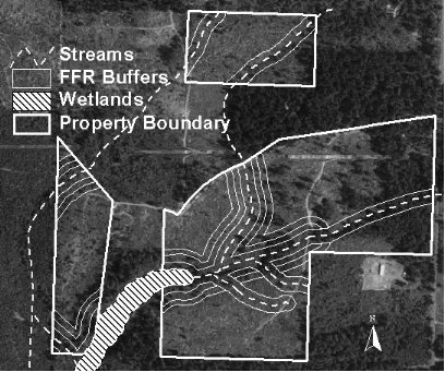
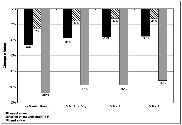
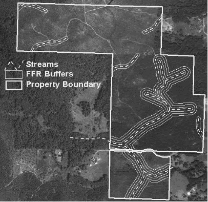
A.4 CASE STUDY 4Case Study 4 (Figure A.4.1) is the largest case study, with approximately 318.6 acres of commercial forestland located in Lewis County, WA. Most of the stands are 5 to 15 years old, and they are predominantly Douglas-fir except for one riparian stand of 40-year-old alder. Site quality is class II, for which the FFR requires a total riparian buffer width of 170 feet on each side of a fish-bearing stream. A small stream that is considered fish-bearing under the FFR runs from north to south and meets up with another fish-bearing stream flowing east to west in the southern portion of the property. There are also several nonfish-bearing streams on the property requiring 50-foot buffers. Under the previous rules none of the streams were considered fish-bearing and no riparian buffers were required. Under the FFR a total of 21% of the property is impacted by riparian buffers, with 15% in the core and inner zones (Table A.4.1). Economic impacts for Case Study 4 are summarized in Table A.4.2, Figure A.4.2, and Figure A.4.3.
A.5 CASE STUDY 5Case Study 5 (Figure A.5.1) is a parcel with approximately 130.2 acres of commercial forestland located in Lewis County, WA. Most of the stands are mixed conifer with an age range of 5 to 50 years. The oldest timber is in the riparian zones. Site quality is class II, for which the FFR requires a total riparian buffer width of 170 feet on each side of a fish-bearing stream. A fish-bearing stream traverses the property from south to north with two other streams feeding into it. A total of 27% of the property is impacted by riparian buffers under the FFR, with 18% in the core and inner zones (Table A.5.1). Economic impacts for Case Study 5 are summarized in Table A.5.2, Figure A.5.2, and Figure A.5.3.
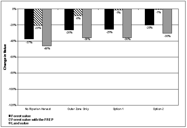
A.6 CASE STUDY 6Case Study 6 (Figure A.6.1) is a parcel with approximately 171.4 acres of commercial forestland located in Lewis County, WA. There are a number of different stands on the property, which range in age from 3 to 47 years old. The predominant species is Douglas-fir, with western redcedar and a mix of hardwoods present as well. Site quality is class II, for which the FFR requires a total riparian buffer width of 170 feet on each side of a fish-bearing stream. A large fish-bearing stream with several tributaries winds through the property, which creates a complex patchwork of riparian areas. A total of 37% of the commercial forest acreage is impacted by riparian buffer zones under the FFR, with 28% in core and inner zones (Table A.6.1). Economic impacts for Case Study 6 are summarized in Table A.6.2, Figure A.6.2, and Figure A.6.3.
A.7 CASE STUDY 7Case Study 7 (Figure A.7.1) is a parcel with approximately 276.4 acres of commercial forestland located in Grays Harbor County, WA. The majority of the timber is 5-year-old regeneration, with some pockets of 40 to 60-year-old timber. The predominant species are western hemlock and western redcedar. DNR forest practices site class maps classify the property as site class III, for which the FFR requires a total riparian buffer width of 140 feet on each side of a fish-bearing stream. However, landowner observations suggest that some stands are actually closer to site IV. Growth model runs for these stands were based on the landowner observations. Two fish-bearing streams originate on the property, join together, and flow out to the north. There is a nonfish-bearing stream in the northeast corner that requires a 50-foot buffer and several wetlands that require wetland management zones (WMZ). A total of 11% of the commercial forest acreage is impacted by riparian buffer zones under the FFR (including WMZ areas), with 7% in the core and inner zones (Table A.7.1). Economic impacts for Case Study 7 are summarized in Table A.7.2, Figure A.7.2, and Figure A.7.3.
A.8 CASE STUDY 8Case Study 8 (Figure A.8.1) is a parcel with approximately 122.4 acres of commercial forestland located in Grays Harbor County, WA. About half of the stands are 40 to 45 years old, with the other half being 10-year-old regeneration. The predominant species in the mature stands is western hemlock, with a mix of western hemlock and Douglas-fir in the regeneration stands. DNR forest practices site class maps classify the property as site class III, for which the FFR requires a total riparian buffer width of 140 feet on each side of a fish-bearing stream. However, landowner observations suggest that the property is actually site I. Growth model runs were based on the landowner observations. Several fish-bearing streams run through the property. A total of 25% of the commercial forest acreage is impacted by riparian buffer zones under the FFR, with 17% in core and inner zones (Table A.8.1). Economic impacts for Case Study 8 are summarized in Table A.8.2, Figure A.8.2, and Figure A.8.3.
A.9 CASE STUDY 9Case Study 9 (Figure A.9.1) is a parcel with approximately 147.6 acres of commercial forestland located in Grays Harbor County, WA. The majority of the timber is 10-year-old regeneration, with some areas of 45 to 50-year-old timber. The predominant species are western hemlock, Douglas-fir, western redcedar, and Sitka spruce. DNR forest practices site class maps classify the property as site class III, for which the FFR requires a total riparian buffer width of 140 feet on each side of a fish-bearing stream. However, landowner observations suggest that some stands are actually site II. Growth model runs for these stands were based on the landowner observations. There are several wetlands on the property that are connected by a fish-bearing stream. Under the FFR, this entire system is considered fish habitat and requires full buffers. The wetland portions are considered large streams, while the rest is treated as a small stream. There are also several wetlands that are not part of the system that only require a wetland management zone (WMZ) and two forested wetlands that do not require any buffering. A total of 21% of the commercial forest acreage is impacted by riparian buffer zones under the FFR (including WMZ areas), with 16% in the core and inner zones (Table A.9.1). Economic impacts for Case Study 9 are summarized in Table A.9.2, Figure A.9.2, and Figure A.9.3.
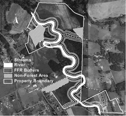
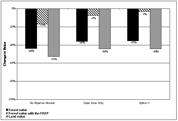
A.10 CASE STUDY 10Case Study 10 (Figure A.10.1) is located along the Humptulips River in Grays Harbor County, WA. A large portion of the site is a wetland, which is surrounded by approximately 163.4 acres of commercial forestland. The predominant species are western hemlock, red alder, and Douglas-fir. Stands range from 25 to 40 years old, except for one 85-year-old alder stand. DNR forest practices site class maps classify the property as site class III, for which the FFR requires a total riparian buffer width of 140 feet on each side of a fish-bearing stream. However, landowner observations suggest that some stands are actually site I. Growth model runs for these stands were based on the landowner observations. A total of 39% of the commercial forest acreage is impacted by riparian buffer zones under the FFR, with 32% in the core and inner zones (Table A.10.1). Economic impacts for Case Study 10 are summarized in Table A.10.2, Figure A.10.2, and Figure A.10.3. Note that because the property is site class III and both the wetland and the Humptulips River qualify as large streams, Option 2 is not applicable.
|
||||||||||||||||||||||||||||||||||||||||||||||||||||||||||||||||||||||||||||||||||||||||||||||||||||||||||||||||||||||||||||||||||||||||||||||||||||||||||||||||||||||||||||||||||||||||||||||||||||||||||||||||||||||||||||||||||||||||||||||||||||||||||||||||||||||||||||||||||||||||||||||||||||||||||||||||||||||||||||||||||||||||||||||||||||||||||||||||||||||||||||||||||||||||||||||||||||||||||||||||||||||||||||||||||||||||||||||||||||||||||||||||||||||||||||||||||||||||||||||||||||||||||||||||||||||||||||||||||||||||||||||||||||||||||||||||||||||||||||||||||||||||||||||||||||||||||||||||||||||||||||||||||||||||||||||||||||||||||||||||||||||||||||||||||||||||||||||||||||||||||||||||||||||||||||||||||||||||||||||||||||||||||||||||||||||||||||||||||||||||||||||||||||||||||||||||||||||||||||||||||||||||||||||||||||||||||||||||||||||||||||||||||||||||||||||||||||||||||||||||||||||||||||||||||||||||||||||||||||||||||||||||||||||||||||||||||||||||||||||||||||||||||||||||||||||||||||||||||