|
 |
 |
 |


Appendix A
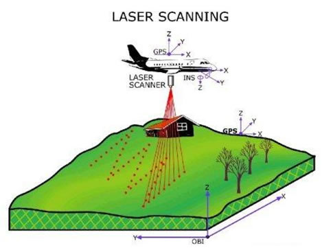
LiDAR System UsedLiDAR (Light Detection And Ranging) data is collected by a well defined flight plan through a specified location. (Appendix Figure A1) LiDAR is a method of detecting distant objects and determining their position or other characteristics by analysis of pulsed laser light reflected from their surfaces. LiDAR works on the same principle as RADAR (Radio Detection And Ranging), but LiDAR uses light waves emitted by a laser (rather than radio waves) to gather data. In its simplest form, LiDAR is used to determine the distance from the laser to a given object.
The data for the study site was collected by TerraPoint which flew a multiple-return scanning laser altimeter in a small fixed-wing aircraft with a circa 0.9 meter on-the-ground laser spot, nominal across- and along-track pulse spacing of 1.5 meters, and 50% overlap of adjacent flight lines, providing an average of circa 1 pulse/square meter. Some of these data (Bainbridge Island) were acquired for Kitsap PUD in 1996-1997. Average pulse spacing of the Bainbridge data was similar. The data are in Stateplane projection, Washington Sorth zone FIPS zone 4602. The vertical datum is NAVD88, horizontal datum is NAD83 HARN. Horizontal units are US Survey Feet. Raster cells (grid cells, image pixels) are 6 ft square. Elevations are recorded in integer feet. |