|
Fact Sheet #25
Alternate Planning for small forest landowners in eastern Washington
under the Forest and Fish Rules
|
August 2003
By Elaine Oneil
| The stated intent of Washington State's "Forest
and Fish Rules" (FFR) for eastern Washington is to provide
restoration of riparian function while allowing activities that
can ameliorate risks associated with fire, disease, and insects
within riparian zones. In addition, the FFR anticipated the
need for alternate plans in situations where risks to aquatic
resources are low and mitigation of economic impacts to small
landowners is desired. Alternate plans must provide equivalent
protection to aquatic resources, yet be simple to implement,
economically desirable, and avoid unintended consequences associated
with eastside disturbance vectors such as bark beetles and fire.
An alternate plan approach was developed using stand density
index (SDI) to integrate the economic, riparian function, and
biological criteria necessary to reduce riparian stand susceptibility
to infestation by Mountain Pine Beetle (Dendroctonus ponderosae,
Hopkins). This approach suggests one possible template for eastside
alternate plans on at-risk stands. Refinement of the approach
that is derived to avoid negative consequences may be a precursor
to developing a desired future condition (DFC) model for the
eastside which integrates variability in habitats and disturbance
regimes to arrive at a dynamic range of optimal riparian conditions.
The eastside dynamic range (EDR) model would reflect the integration
of disturbance variables, such that stands would be placed on
a trajectory toward long-term sustainability rather than away
from risk avoidance. |
 |
|
Analysis of the potential economic impacts of increasing
riparian protection under the FFR was completed using a case
study approach. Under the FFR there is considerable variability
in economic impact among landowners in eastern Washington
(see Factsheet 20) with owners losing up to 49% of the economic
value of their holdings. This outcome is particularly apparent
in drier and poorer ecosystems where basal area increase takes
a substantial time period or where stands have high tree densities,
but few trees exceeding 10" dbh.
Given the negative economic outcomes under the FFR and the
funding uncertainties under the FREP (see Factsheet 2), pursuing
an alternate plan is an option landowners can choose to provide
habitat value in a more cost effective manner. Alternate plans
(AP) are permitted in specific situations, such as disproportionate
levels of impact, or on a small harvest unit, but they must
provide 'protection to public resources at least equal in
overall effectiveness as provided by the act and rules' (WAC
222-12-040). In effect AP must consider economic viability,
and riparian stand biological condition. In the absence of
an eastside DFC model, AP for eastern Washington have been
developed to place riparian stands on a growth trajectory
to reduce their susceptibility to loss from disturbance vectors.
As an example, the biological conditions that precipitate
Mountain Pine Beetle (MPB) infestations are explored for a
low site class riparian zone in Okanogan County to determine
the most appropriate approach for alternate planning under
such circumstances. In the long term, an eastside dynamic
range (EDR) model that is based on inherent disturbance regimes
(Everett et al. 2000) might be preferable.
Literature on MPB risk and susceptibility indicates that
stands move into the range of susceptibility to insect infestations
at approximately 80-100 ft2/ac of basal area (Cochran
1988, Larsson et al.1983, Schmid and Mata 1992). When examining
the potential for insect attack, the literature indicates
that variability in site quality also drives insect infestation
with drier and poorer ecosystems experiencing mortality at
lower stocking levels (Cochran et al. 1994). Vigor indices
indicate that for low site classes, the lower limit of susceptibility
is approximately 85 ft2/acre (Cochran 1988). These
susceptibility ranges and vigor indices suggest that the threshold
of bark beetle susceptibility is between the upper and lower
basal entry limits for inner riparian zone management under
the FFR. Post harvest outcomes that meet FFR requirements
for basal area and trees/acre are given in Figure 1 for all
low elevation case study sites in the original analysis. Figure
1 demonstrates that 75% of managed riparian stands will remain
very close to the MPB threshold or in many cases exceed it
under the FFR. Stands will exceed this limit, even at completion
of harvest, when the combination of minimum tree count and
21 largest tree requirement result in basal area retention
exceeding 85 ft2/acre of basal area. Basal area
growth between harvest entries will always exceed this limit
of susceptibility because re-entry is not permitted until
the upper basal area limit established under FFR is reached.
|


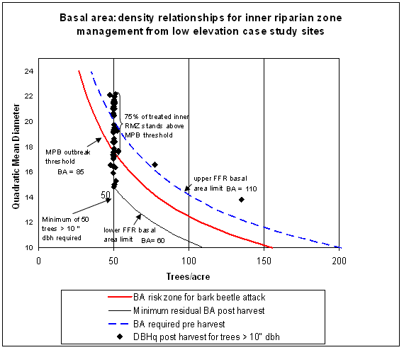
| Figure 1: |
BA distribution
post harvest for riparian inner zones in low elevation case
study sites under the FFR. |
Outcomes depicted in Figure 1 suggest that AP that
alter stand density and thus mitigate insect dynamics while still
meeting economic and riparian functional requirements are needed.
In determining appropriate thresholds, AP to address MPB risk
must consider "stockability". Stockability refers to
the inherent biological carrying capacity of the site which can
be inferred from the plant association or habitat type (Cochran
et al. 1994, Fiedler et al. 1988). Stockability measures are derived
relative to 'normal' or full stocking using site index (SI), maximum
SDI, and growth basal area (GBA) (Cochran et al. 1994). The types
of relationships between inherent carrying capacity of low productivity
sites and insect attack identified in the figures and literature
would indicate that AP on low productivity sites should look at
maintaining lower basal areas than those that occur under the
FFR criteria, given current stand conditions. In addition, linking
harvest timing to mortality indices and basal area increment decline
rather than FFR upper basal area limits, could reduce the stand
stress that is a precursor to MPB infestation. Under the FFR,
riparian function is maintained using 5 key leave tree requirements:
minimum BA, TPA and DBH, upper BA limit, and largest tree requirements.
Collectively, these variables can be described using stand density
index or SDI, which forms a baseline metric for comparison of
disparate stand conditions to the riparian functional requirement.
Stand density index (SDI), as given by the equation SDI = TPA(DBHq/10)1.6,
gives a relative density measure of the number of 10" trees/acre
of land (Reineke 1933). Calculating a SDI for the FFR riparian
requirements of 50 TPA> 10" and a basal area of 60 square
feet/acre gives a SDI value of 95. For low elevation stands, the
minimum acceptable target SDI is 95 with only trees >10"
dbh considered acceptable in meeting riparian functional requirements.
With alternate planning, the options for meeting the SDI requirements
can be expanded by considering the dual metrics of stand density
(TPA) and quadratic mean diameter (DBHq). Table 1 outlines the
relationship between these metrics in meeting the SDI goal of
95. It should be noted that in all cases the basal area for a
SDI of 95 is below the threshold for MPB infestation for either
ponderosa or lodgepole pine. If we use the SDI of 95 as an acceptable
measure of riparian functionality and treat the riparian zone
in case study 7, a site in Okanogan County that continues to experience
mortality from mountain pine beetle, the metrics are given in
Table 2. If riparian function is given by a SDI of 95, then these
riparian stands largely meet or exceed that goal. The stands also
maintain a basal area below that of the susceptibility level for
MPB. Table 3 compares the economic outcomes relative to the baseline
under FFR and the AP developed to address riparian functional
requirements while addressing bark beetle risk for Case 7.
| Table 1: |
Options for meeting
a Stand Density Index goal of 95. |
|
| Table 2: |
Range of riparian stand
metrics over a 90 year simulation period for Case 7 |
|
|
SDI
|
TPA
|
DBHq
|
BA
|
| |
95
|
95
|
10
|
52
|
| |
95
|
82
|
11
|
54
|
| |
95
|
71
|
12
|
56
|
| |
95
|
62
|
13
|
58
|
| |
95
|
55
|
14
|
59
|
| FFR |
95
|
50
|
14.9
|
60
|
| |
95
|
50
|
15
|
61
|
| |
95
|
45
|
16
|
63
|
| |
95
|
41
|
17
|
64
|
| |
95
|
37
|
18
|
66
|
| |
95
|
34
|
19
|
67
|
| |
95
|
31
|
20
|
68
|
| |
95
|
29
|
21
|
70
|
| |
95
|
27
|
22
|
71
|
| |
95
|
25
|
23
|
72
|
| |
95
|
23
|
24
|
74
|
|
|
metric
|
DBHq >6" dbh
|
TPA >6" dbh
|
TBA
|
SDI
|
| average |
11.9
|
75
|
58.2
|
116
|
| max |
14
|
117
|
66.5
|
141
|
| min |
9.8
|
49
|
51
|
97
|
| Table 3: |
Percentage change of
NPV (as compared to the baseline) over 90 years between
FFR and an AP for Case 7 that addresses MPB risk. |
| Scenario |
% change |
| No Riparian Harvest |
-9%
|
| Inner Zone Single Entry |
-10%
|
| Alternate Plan |
10%
|
|
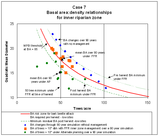
Mortality and stand basal area growth rate declines
were apparent in the simulation results for Case 7 once the stands
exceed 80-90 square feet of basal area/acre. This decline is consistent
with the literature which indicates that growth rates, as determined
by basal area increment, decline at these stocking levels (Fiedler
et al.1988, Larsson et al. 1983). Alternate plan strategies for
Case 7 used the simulated growth rate decline as an indicator
for riparian stand entry which meant that stand entry occurred
prior to meeting the required upper basal area limit. At entry,
a SDI of approximately 95 with approximately 50-60 square feet
of basal area and 50 trees > 10" dbh were retained. Limits
on leaving the 21 largest trees were ignored to effect basal area
reduction without excessive loss of tree cover necessary to meet
shade requirements. A comparison of the outcomes for FFR and the
AP are given in Figure 2. Figure 2 indicates that the average
stand condition over 90 years under the FFR scenario is on the
isoline where mortality from MPB can be expected. Under a no management
scenario, as would occur in the core zone, stands fall below the
MPB risk zone in only 1 of 9 decades. In contrast, the AP scenario
maintains an average basal area below the MPB risk level in all
decades. For case study 7, the alternate plan is much more likely
to address a currently existing MPB infestation than the FFR.
The alternate planning approach used in this example could be
applied for many situations where stocking control is desirable
to avoid the unintended consequences of MPB infestation within
riparian zones. Given the range of options in the look-up table
(Table 1) for low elevation sites, optimal solutions regarding
the number and size of leave trees can be varied to address specific
LWD or shade requirements on a specific stream reach.
Conclusions
The stated intent of the rules in eastern Washington is to
provide for restoration of riparian function while allowing
activities that can ameliorate risks associated with disturbance
agents within riparian zones. The development of AP that address
susceptibility factors associated with MPB infestation while
meeting riparian habitat requirements provide a potential solution.
Adoption of a multi-metric approach that considers the equivalency
of SDI across acceptable tree diameter classes can provide a
mechanism to achieve risk reduction for multiple resource values,
while improving economic consequences. Sensitivity analysis
indicated that the growth models used in this analysis responded
to site and habitat type parameters; this information can be
used to tailor AP by habitat type to better reflect biological
limits and stressors. In the long term, an eastside dynamic
range model (EDR) might be a more comprehensive approach than
risk avoidance approaches.
| Figure 2: |
Basal area relationships under
AP and FFR scenarios for Case 7 riparian zones. |
-
Cochran, 1988, Stocking Levels for Managed
even-aged stands of Ponderosa Pine in Baumgartner David
M. and James E. Lotan eds., Ponderosa Pine - The Species and
its Management, Symposium Proceedings, Sept 29-Oct 1, 1987,
Spokane WA, WSU Cooperative Extension, Pullman WA.
-
Cochran, P.H., J.M. Geist, D.L, Clemens, Roderick
R. Clausnitzer and David C. Powell, 1994, Suggested stocking
levels for forest stands in northeastern Oregon and southeastern
Washington., USDA Forest Service, PNW Station, Research Note
#513. (PNW-RN-513, April 1994).
-
Everett, R.H., J. Townsley, and D. Baumgartner,
2000, Chapter 11: Inherent Disturbance Regimes: A Reference
for Evaluating the Longterm Maintenance of Ecosystems in
Journal of Sustainable Forestry, 11(1/2):265-288.
-
Fiedler, Carl, Roland Becker and Steve Haglund,
1988, Preliminary Guidelines for Uneven-aged Silvicultural
Prescriptions in Ponderosa Pine in Baumgartner David M.
and James E. Lotan eds., Ponderosa Pine - The Species and its
Management, Symposium Proceedings, Sept 29-Oct 1, 1987, Spokane
WA, WSU Cooperative Extension, Pullman WA.
-
Larsson, S., R. Oren, R.H. Waring, J.W. Barrettt,
1983, Attacks of Mountain Pine Beetle as Related to Tree Vigor
of Ponderosa Pine, Forest Science 29(2):395-402.
-
Reineke, L.H., 1933, Perfecting a stand density
index for even-aged forests, J. Agric Res. 46:627-638.
-
Schmid, J.M. and S.A. Mata, 1992, Stand Density
and Mountain Pine Beetle caused Tree Mortality in Ponderosa
Pine Stands, USDA Forest Service, Rocky Mountain Forest and
Range Experimental Station, Research Note #515.. (RN-RM-515,
Mar 1992).
-
WAC 222-12-040, 2001, Washington Administrative
Code § 222-12-040 Alternate Plans - Policy.
|
|