|
2001
Luke Rogers and Matthew McLaughlin
Save
or Print a PDF copy of Fact Sheet #05
|
|
In House Bill 2091 the Washington State Legislature authorized
the creation of the Department of Natural Resources Small Forest
Landowner Office (SFLO). In that same bill, Legislators also
authorized the creation of a database on non-industrial private
forestland (NIPF) that could provide reliable reports assessing
ownership patterns such as information on watershed coverage,
forest management and housing. In April 2001, Rural Technology
Initiative (RTI) staff began development of the database with
the support of the Department of Natural Resources and consulting
organizations.
What is the Small Forest Landowner Database?
The SFLO database is a complete record of parcels designated
as non-industrial land in Washington State. The data has
been
collected from the assessor's office of every county in Washington
that contains timberlands or forestlands. RTI staff converted
thousands of records from 34 separate county databases into
a single common format using Microsoft Access® and the
Visual Basic programming language. The state will use information
produced by the database to evaluate the effects of new regulations
on the NIPF and to help support adaptive management legislation.
|
Overview of the Database
House Bill 2091 requires that the Department of Natural Resources
Small Forest Landowner Office assemble reports every 4 years
detailing the current population of NIPF landowners, their acreage
and where they are located. Understanding how the database would
be used was critical to its design and construction. Data in
the database includes the parcel's owner information, location,
size, land classification, watershed, and residence information.
- The owner's information will provide the Legislature with
Washington's first statewide NIPF mailing list, enabling
them to contact those affected by new regulations.
- The parcel location is accurate down to the quarter section
of its township, section and range.
|
- The watershed of the parcel can be found by putting its location
data into a specially made program that utilizes GIS technology
to connect the parcel to a specific watershed.
- Parcel size and land classification are both common characteristics
that can be used to further assess the number of NIPF affected
by new regulations, and better allocate economic relief
to the owners most affected.
- Over time the database will likely also illustrate a growing
concern among non-industrial owners - conversion from forestland
to other uses is occurring at an alarming rate and that
contrary to the goal of forest practice regulation, the
increasing rules are forcing that trend.
|


The SFLO-NIPF Database Can Answer Questions Like:
- How many NIPF owners of less than 20 acres are there
in the Skykomish River watershed? Of these, how many are
located in Snohomish County? King County?
- What is the average forested parcel size within the Little
Naches watershed? What percentage of parcels are 40 acres
or less? Greater than 40 acres?
- Where are NIPF located? Are they at the urban interface?
Are they on the ridge tops or in the valley bottoms? Do
their lands have more or less streams than industrial lands?
Are NIPF disproportionately affected by the new regulations?
- How many NIPF are there in King County? Eastern Washington?
Washington State?
|
- What is the conversion rate of non-industrial lands to
other uses and how has it changed with regulations?
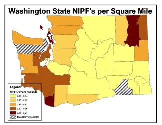
Figure 1 - NIPF owners per square mile. Stevens and Island
Counties have the most. |
Summary
With the passing of the Salmon Recovery Act, the Department of Natural
Resources realized a need for a database of the state's NIPF to
track effects of new regulations. The Rural Technology Initiative,
with the help of the Small Forest Landowner Office and other consultants,
was able to design and construct a database that can answer questions
mandated by House Bill 2091. With further verification of data validity
at the county level, the SFLO database will be an important resource
of NIPF information for the state of Washington.
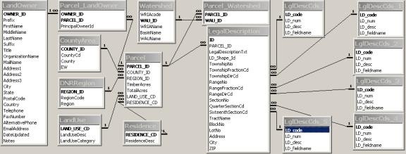
Figure 2 - The SFLO-NIPF database tables and their associations
with each other.
|