|
 |
 |
 |


Project Brief:
Small Forest Landowner Parcel Identification and County GIS Data Compilation for Washington State WRIAs 23 & 49
Prepared For:
Melody Tereski
Program Manager
Lower Columbia Fish Recovery Board
2127 8th Ave
Longview, WA 98632
(360) 425-1555
melodyt
Prepared By:
Luke Rogers
Senior Research Scientist
Rural Technology Initiative
University of Washington – College of Forest Resources
Box 352100
Seattle, WA 98195-2100
(206) 543-7418
lwrogers Executive SummaryWashington’s non-industrial private forestlands represent over half of the total private forestland in the State. Lower in elevation than industrial forestlands, these parcels are often found in the spawning regions of many of Washington State’s salmon streams and present an excellent opportunity for cost-share and assistance programs aimed at habitat access and restoration. The Washington State Department of Fish & Wildlife has teamed with many local fish enhancement groups like the Lower Columbia Fish Recovery Board to identify existing fish blockages and habitat enhancement opportunities. What is unknown is where the non-industrial lands that qualify for assistance programs are located. A Geographic Information System (GIS) based approach to locating Non- Industrial Private Forestlands (NIPF) using county assessor tax roles, GIS parcels, Landsat satellite imagery, and aerial photography has been developed to assist in the prioritization and identification of habitat enhancement opportunities on NIPF lands. This approach identifies certain and probable non-industrial lands and allows local fish enhancement groups to prioritize work and contact individual landowners. Table of Contents
List of Figures
List of Tables
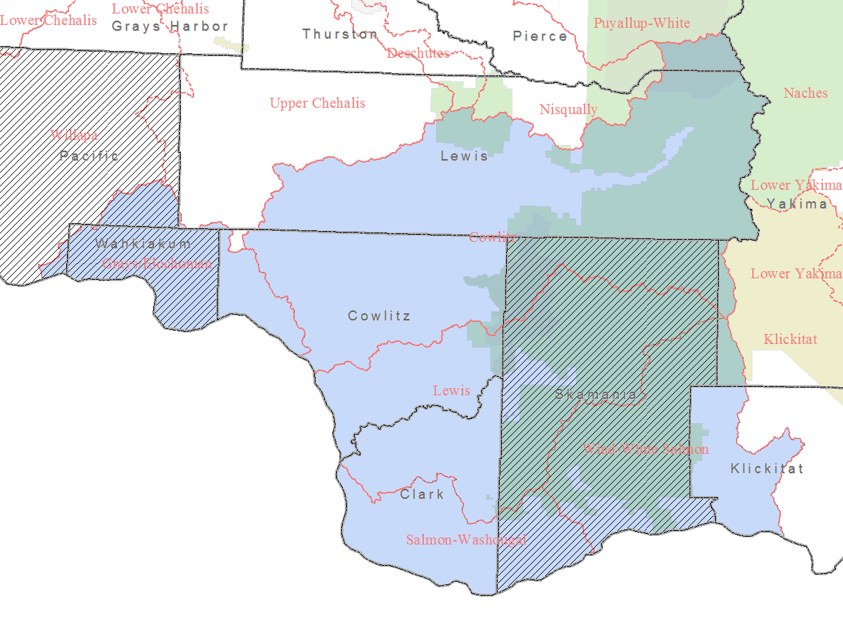
IntroductionRestoration of Washington’s threatened and endangered salmon runs can be assisted by focusing restoration efforts in areas where the most habitats can be created for the least cost. The Washington State Department of Fish & Wildlife as well as many local fish enhancement groups like the Lower Columbia Fish Recovery Board have come together to locate and survey many of the State’s salmon streams. These surveys have produced Geographic Information System (GIS) layers that show the location, condition and fish passage ability of dams, culverts, and fishways around the state. This information, combined with knowledge of who owns the land, can help local groups and funding agencies to identify target restoration areas. Currently, there are many assistance programs targeted specifically at Non-Industrial Private Forestlands and Small Forest Land Owners. Many of the financial assistance programs are targeted only at Small Forest Landowners. However, the definition of small forest land owners (SFLO) makes it difficult to identify them without door-to-door surveys. The State of Washington’s harvest-based definition of a small forest landowner created in the Salmon Recovery Act, defines small forest landowners as those who harvest less than two million board feet on an annual basis. [RCW 76.13.120(2)(c)]. A previous acreage-based definition considers non-industrial forests and woodlands (NIPF) as “those suburban acreages and rural lands supporting or capable of supporting trees and other flora and fauna associated with a forest ecosystem, comprised of total individual land ownerships of less than five thousand acres and not directly associated with a wood processing or handling facilities” (RCW 76.13.010(4)). The currently available generalized information on harvests is not detailed enough to locate or identify small forest land owners. Therefore, the acreage-based definition of non-industrial private forests will be used to identify these ownerships. Identification of these NIPF lands is based on two assumptions: land uses taxed as forestland meet the NIPF definition, and forested lands that have non-conflicting land uses likely meet the NIPF definition. County assessor tax roles and GIS parcels (where available) were used to identify the parcels that have land uses taxed as forestland. Landsat satellite imagery was classified into forest and non-forest categories to identify forested parcels. Those parcels were then intersected with non-conflicting land use parcels to identify those parcels that were mostly forested and had non-conflicting land uses. These additional forested parcels could be considered as probable NIPF lands. In this brief project summary, we describe the data used in this analysis, the methods used to determine non-industrial private forestlands, and give some general statistics about these NIPF lands. DataOf the 7 counties (Clark, Cowlitz, Lewis, Pacific, Pierce, Skamania, Wahkiakum, and Yakima) in Water Resource Inventory Areas (WRIAs) 25 – 29 only Clark, Cowlitz, Lewis, Pierce, and Yakima had publicly available GIS parcel data. The portions of the Cowlitz and Lewis WRIAs that were in Pierce and Yakima Counties are Federal land so only Clark, Cowlitz, and Lewis Counties were fully analyzed. The portions of the WRIAs in Pacific, Skamania, and Wahkiakum could not be fully analyzed so data for those Counties was extracted from the non-spatial 2001 Department of Natural Resources Small Forest Landowner Database.
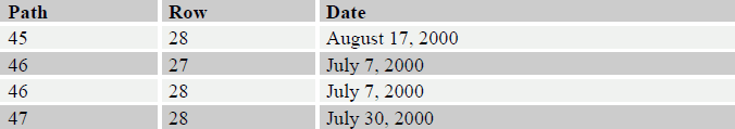
Landsat data used for the analysis was acquired as part of the Washington State Remote Sensing Consortium 2000 Landsat purchase. All three of the scenes used for the analysis were acquired in the summer of 2000, see Table 1. The images are mostly cloud-free but there were a few areas where clouds obscured the land. In these areas, land cover could not be identified.
Orthographically corrected digital aerial photography used to create training datasets for the forest classification was acquired form the US Geological Survey and the US Forest Service. Image acquisition dates for the ortho-photography range from 1996 to 2001. AnalysisNon-industrial private forestlands are identified using two methods. The first method uses only the county assessor’s tax roles to identify parcels that have land uses taxed as forestland. The second method uses Landsat imagery to construct a forestland layer which is compared with non-conflicting land use parcels in the county assessor’s tax roles. Both methods rely on local knowledge of the forest industry to eliminate those forest enterprises that are not non-industrial. County assessors typically follow a land use tax scheme that is closely related to the State’s land use coding scheme. Although there are some variations the land uses that are typically found relating to forestland are: 87 - Classified forest land, 88 - Designated forest land, 92 - Noncommercial forest, 94 - Open space land, and 95 - Timberland. According to county assessors, these tax designations indicate that a parcel is being managed as forestland. Owners like Weyerhaeuser, Boise Cascade, Longview Fibre and other owners with more than 5000 acres are taxed as forestland but obviously not considered NIPF and are removed from the NIPF land base. This method yields a very high confidence that the identified parcels are indeed non-industrial private forests.
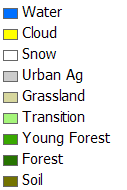
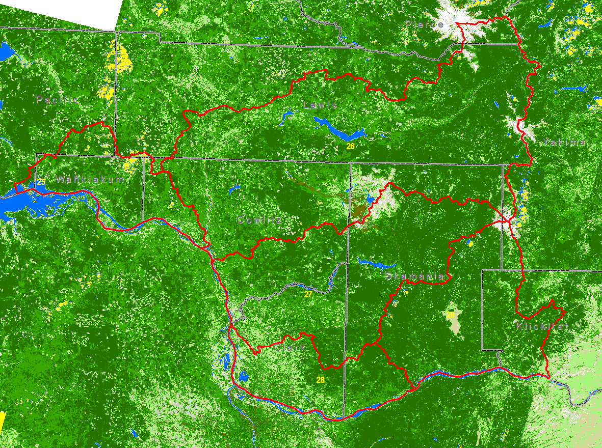
Identification of NIPF parcels that are not taxed as forestland requires additional analysis based on land cover. The land cover analysis uses ERDAS Imagine 8.7 and Landsat 7 Enhanced Thematic Mapper satellite imagery. The satellite images are first converted to reflectance to remove atmospheric effects and then topographically normalized to remove the effects of topographic shading in the imagery. Orthographically corrected aerial photographs are visually interpreted to create training datasets for image classification. The images are then classified into nine basic classes, see Figure 2 and Figure 3, and then aggregated into forest/non-forest categories. Areas classified as transition, typically clear-cuts, were counted in the non-forest category to account for any possible conversion activity to non-forest uses. An accuracy assessment of the nine classes using random points shows that over 90% of the pixels are classified correctly. When aggregated into forest/non-forest, the accuracy is better than 96%.
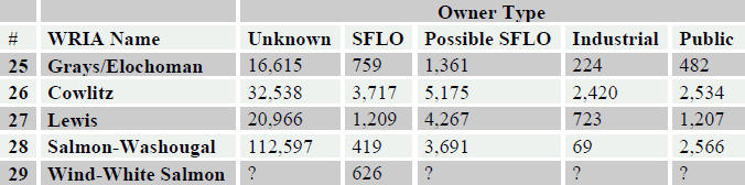
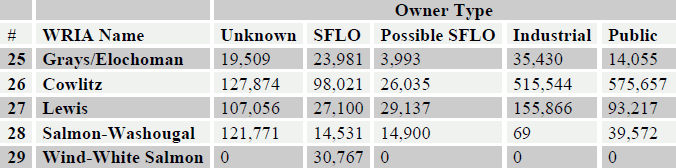
It is known from Washington State University surveys and from discussions with landowners that somewhere around half of Washington’s non-industrial private forests are not in forest tax classifications. These parcels typically have land uses that do not conflict with forestry. For this analysis we focus on assessor land use codes of: 89 – Other resource protection, 91 – Undeveloped land, and 99 – Other undeveloped land. Overlaying the forest/non-forest layer on these non-conflicting land use parcels enables the calculation of percent forest. For this analysis we considered any parcel with a nonconflicting land use that was at least 75% forested to be a potential non-industrial private forest. Counties store assessor parcel data in many different formats including ArcSDE, Geodatabases, Coverages and Shapefiles. In addition to storing the data in different formats, every County uses different attributes with diverse values. These differences make inter-county analyses difficult and inconsistent. To assist end uses of the data with their analyses, a single cross-county format was created. This cross-county format includes information like the owner name and address, the parcel size, land use, location and taxes. ResultsCombining assessor tax roles with remote sensing techniques yielded about four times as many candidate non-industrial private forests compared to only using assessors tax roles. However, it is unlikely that very small parcels are NIPF. The State’s minimum size for small forest landowner eligibility is 5 acres. Eliminating possible NIPF parcels under 5 acres yields about twice the number of candidate NIPF parcels compared to only using assessors tax roles. Table 2 and Table 3 show the number and acres of parcels by owner type for Clark, Cowlitz and Lewis counties within WRIAs 25 – 29. The SFLO numbers and acres in the tables also include data from the 2001 DNR Small Forest Landowner Database.
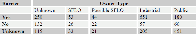
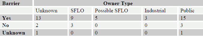
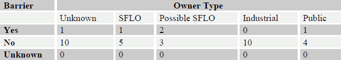
Barrier information from the Washington State Department of Natural Resources for WRIAs 25 – 29 within Clark, Cowlitz and Lewis Counties were overlaid on the potential NIPF parcels. The inventoried in-stream features include culverts, dams and fishways. Statistics for each type of in-stream feature can be found in Table 4, Table 5, and Table 6. Table 4 - Culvert barrier status by owner type.
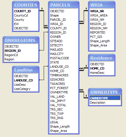
Data UsageThe results of this project are provided in two primary datasets (with associated lookup tables) and ten maps. Lookup tables can be joined to the Parcels and SFLODB tables for reporting or display. The relationships between the tables can be seen in Figure 4. The primary GIS tables and their associated lookup tables are briefly describe below.
For example, to select the small forest landowners and the possible small forest landowners from the parcel table in ArcView 3.x the query would be: “(( [Ownertype] = 1) or ([Ownertype] = 2 )) and ([Gisacres] > 5)”
Conclusion & RecommendationsUtilizing county assessor tax roles is an effective way to identify Washington State Non- Industrial Private Forests. However, many of Washington’s NIPF are not taxed as forestland. Often, owners are not aware of the tax benefits associated with a forest tax classification or their parcel is too small to realize the benefit. It is estimated from surveys that there are likely twice as many non-industrial private forests in Washington State as can be identified solely from county assessor tax information. Identification of these parcels and their owners can be assisted by using remote sensing techniques (to identify forestland) in combination with county assessor tax information. Assuming that large forested parcels with non-conflicting land uses are likely non-industrial private forestlands yields almost twice as many potential non-industrial private forests and is much closer to the numbers that surveys have estimated. Validation of this method of identifying non-industrial private forests requires on-theground surveys of land owners. The outreach efforts of local fisheries enhancement groups can help to verify the validity of this approach. Future efforts to identify NIPF using remote sensing and assessor tax roles could benefit from information gained from these local groups. |