|
Welcome to the Washington State Forestland Database Downloads page. The Database was created to produce valuable information that can be used to improve decision making. Open distribution to stakeholders is an important element to the long term success of the database. However, Due to the sensitive nature of the information contained in the database, access to the files is closely monitored.
Downloading the Data
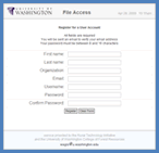
In order to download the Washington State Forestland Database, users must register for a UW File Access account. You will be asked to provided your name, a valid email, and your Organization. You will need to confirm your email. After your email has been confirmed, administrators will approve you for access to the requested Database. Click here to register.
If you receive a warning about a certificate error you can safely ignore it or install the University of Washington root certificate. We use SSL encryption to ensure data is sent securely between the RTI server and your browser. Installing the UW root certificate does not increase security but it will make those annoying "certificate error" warnings go away.
If you already have an account, you can access files for which you are approved by logging in. You will be prompted to enter your registered login information when you click to download data below.
Washington State Forestland Database
Version 2007, Release 2.0
What’s included in the 83MB zip file?
Included in this .zip file are the Forestland Database, the official Database report, and three example summary statistic layers. The database is provided in Microsoft Access 2002-2003 / ArcGIS 9.2 format.
Within the Database itself are three spatial feature classes, and four tables.
The three spatial feature classes are:
- Washington Department of Natural Resources Counties, County_2007
- Washington Department of Natural Resources Watershed Administrative Units, WAU_2007
- Washington Department of Ecology Water Resource Inventory Areas, WRIA_2007
The primary Forestland data is provided in the table Forestland_2007. The three other tables provide example summary statistics. Forestland data can be summarized to Counties, WAUs, or WRIAs using the provided spatial feature classes.
The included example layers and tables demonstrate the number of forest acres in each County, WAU, and WRIA.
Detailed information about the attributes in the Forestland_2007 table and how the database was produced are available in the official report.
Below is a link to download the 83MB .zip file. The download time will vary depending on your connection speed.
https://www.ruraltech.org/products/download.php?file=B5ED6FB1-D7AA-4B18-8539-D090E4145B39
|


